-
Murales SherbrookeUne galerie d'art
à ciel ouvert!

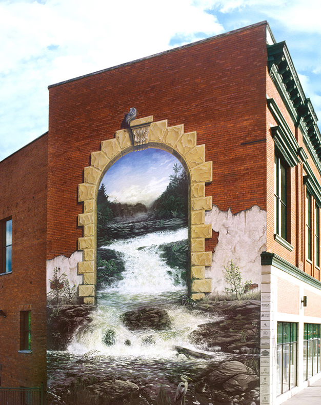
Nékitotegwak - EN
Nékitotegwak

Dimensions : 68 by 29 feet
Year created : 2010
the mural in more detail...
1
Sherbrooke's Location
The present-day Sherbrooke area was geologically fashioned by the elements over millions of years and only assumed its modern form approximately 10,000 years ago. Its rounded hills, plateaus, lakes and rivers emerged following the last ice-age deglaciation.
The melting of glaciers, growth of vegetation and appearance of wildlife attracted American Indians, who began to explore the area using numerous rivers. In the 1650s, nomadic Mohawk and Abenaki families took to the Mamrabagak (Magog) and Alsigantekw (Saint-François) rivers each season on their fishing, hunting, and trapping expeditions.
2
First Nations
The First Nations were drawn by the area’s abundant game, fish and wild fruit. The wildlife included raccoons, North American Elks, hares, and lynxes. But it is the Castor canadensis or Canadian beaver—our national emblem—that most transformed the landscape, by building dams and especially by becoming the first resource in the country to be exploited by Europeans. Its fur was so valuable that it was exchanged as currency. This small rodent was to a large extent the driving force behind the colonization of the Canadian territory.
3
Where the Rivers Meet
Portage, forced by the Magog River’s waterfalls, made the confluence of rivers a strategic place for American Indians as much as for the French, English and New Englanders.
The “place where the rivers meet” became an important stopping point on trips and expeditions, since, after the portage up the Magog River gorge, paddlers could get to Lake Memphremagog, then reach the waters of the Champlain Lake and make their way to Connecticut.
The American Revolution brought on considerable northward population shifts to what would later become the Eastern Townships, a region coveted by many groups of hopeful settlers.
The soil here was mediocre, but the region was promising for dams and hydroelectric power.
4
Clearing
The year 1799 marked the first mention in Sherbrooke history of a project to clear an 18-acre stretch of land. The aspiring pioneer was Jean-Baptiste Nolin. During these times, Gilbert Hyatt also settled in the area to develop the industrial and commercial potential of the river forks.
Working together with Jonathan Ball, Hyatt made the historic gesture of creating the first dam, which gave rise to the small village of Hyatt’s Mills in 1802. This small village was renamed Sherbrooke in 1818, in honour of then-governor Sir John Coape Sherbrooke.
1
Sherbrooke's Location
The present-day Sherbrooke area was geologically fashioned by the elements over millions of years and only assumed its modern form approximately 10,000 years ago. Its rounded hills, plateaus, lakes and rivers emerged following the last ice-age deglaciation.
The melting of glaciers, growth of vegetation and appearance of wildlife attracted American Indians, who began to explore the area using numerous rivers. In the 1650s, nomadic Mohawk and Abenaki families took to the Mamrabagak (Magog) and Alsigantekw (Saint-François) rivers each season on their fishing, hunting, and trapping expeditions.
The melting of glaciers, growth of vegetation and appearance of wildlife attracted American Indians, who began to explore the area using numerous rivers. In the 1650s, nomadic Mohawk and Abenaki families took to the Mamrabagak (Magog) and Alsigantekw (Saint-François) rivers each season on their fishing, hunting, and trapping expeditions.
2
First Nations
The First Nations were drawn by the area’s abundant game, fish and wild fruit. The wildlife included raccoons, North American Elks, hares, and lynxes. But it is the Castor canadensis or Canadian beaver—our national emblem—that most transformed the landscape, by building dams and especially by becoming the first resource in the country to be exploited by Europeans. Its fur was so valuable that it was exchanged as currency. This small rodent was to a large extent the driving force behind the colonization of the Canadian territory.
3
Where the Rivers Meet
Portage, forced by the Magog River’s waterfalls, made the confluence of rivers a strategic place for American Indians as much as for the French, English and New Englanders.
The “place where the rivers meet” became an important stopping point on trips and expeditions, since, after the portage up the Magog River gorge, paddlers could get to Lake Memphremagog, then reach the waters of the Champlain Lake and make their way to Connecticut.
The American Revolution brought on considerable northward population shifts to what would later become the Eastern Townships, a region coveted by many groups of hopeful settlers.
The soil here was mediocre, but the region was promising for dams and hydroelectric power.
4
Clearing
The year 1799 marked the first mention in Sherbrooke history of a project to clear an 18-acre stretch of land. The aspiring pioneer was Jean-Baptiste Nolin. During these times, Gilbert Hyatt also settled in the area to develop the industrial and commercial potential of the river forks.
Working together with Jonathan Ball, Hyatt made the historic gesture of creating the first dam, which gave rise to the small village of Hyatt’s Mills in 1802. This small village was renamed Sherbrooke in 1818, in honour of then-governor Sir John Coape Sherbrooke.
Working together with Jonathan Ball, Hyatt made the historic gesture of creating the first dam, which gave rise to the small village of Hyatt’s Mills in 1802. This small village was renamed Sherbrooke in 1818, in honour of then-governor Sir John Coape Sherbrooke.


